Big Bend National Park
Sunday, 3/15

Not sure where you would put the "Wall" here.....
We didn't see much local wildlife (other than cows and deer), but we did see a road runner up close and personal.

There is an actual border crossing at Boquillas, with a customs and immigration office. You can go from the park to the little town in Mexico, either by wading across the river or being ferried in a rowboat. But you have to have all of your valid travel documents, and I didn't bring my passport. (And the way things were going, it wasn't a sure thing that you could get back.....)
We woke up to drizzle and headed for Big Bend. Our drive to Pecos, TX confirmed my idea that there was an oil boom going on in this area. There was a lot of truck traffic (and road construction), but the thing that stood out the most were all of the areas of temporary housing - clusters of 100 or 200 modular homes parked next to each other. We probably saw a dozen of them along our drive. (It turns out this area of New Mexico and Texas is part of the Permian Basin - much larger than I thought).
The drive was not too bad - traffic thinned out after Pecos, and once we got south of Fort Stockton, there wasn't much - a few very large ranches, but not much else (no gas stations or restaurants until you get to the park.)


We came in the east entrance and made it to the Fossil Discovery Exhibit, which was quite impressive (to us). It was all open air, and the exhibits were all about dinosaurs whose fossils were found in the area. It was a good blend of pertinent information, but not too much.

Check out the flying dinosaur skeleton on the ceiling! Below - A nice windscreen at the picnic area....


Check out the flying dinosaur skeleton on the ceiling! Below - A nice windscreen at the picnic area....

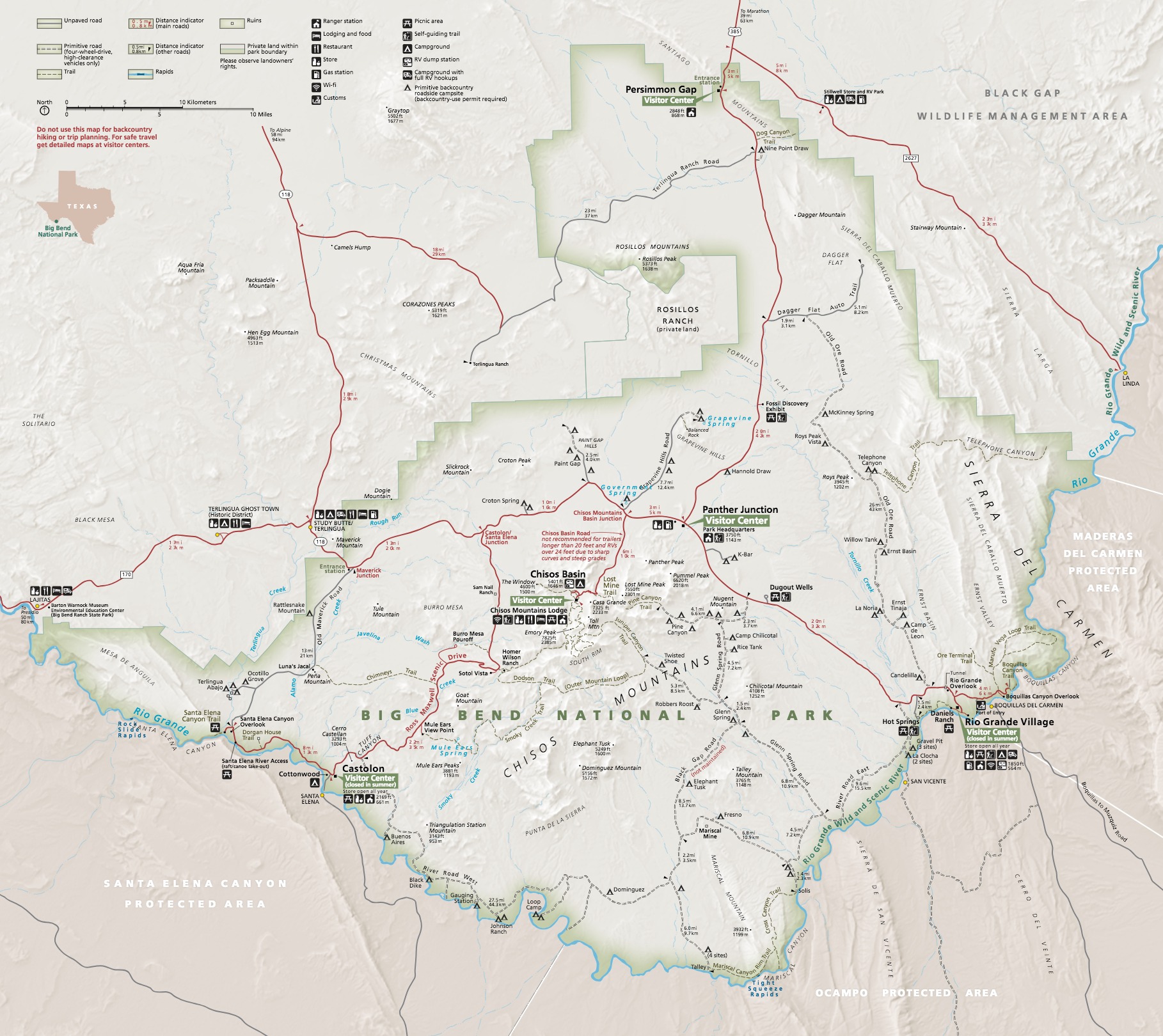
The park is very large. I think it was about 50 miles down to the Rio Grande Village and the another 60 or 70 to our hotel in Terlingua. If you want an idea as to the layout of the park, the following link shows the park map: Big Bend Map
We then drove down to Rio Grande Village, where we hoped to get some lunch. It turns out, there is really not much there but a campground. We did get some ice cream (and gas) at the campstore.
We then drove down to Rio Grande Village, where we hoped to get some lunch. It turns out, there is really not much there but a campground. We did get some ice cream (and gas) at the campstore.
So, we took a little trail down to the Rio Grande River. It certainly seemed like you could just walk across if you wanted to. (Susie saw someone ride across on a horse (from US to Mexico). We met a family from Montreal who were on a 6 month trip to the US (about 1 1/2 months in). They purchased a RV and were going to sell it when they returned. They were a little concerned about the coronavirus, but figured they were pretty much self-isolating in their RV.

Not sure where you would put the "Wall" here.....
We didn't see much local wildlife (other than cows and deer), but we did see a road runner up close and personal.

There is an actual border crossing at Boquillas, with a customs and immigration office. You can go from the park to the little town in Mexico, either by wading across the river or being ferried in a rowboat. But you have to have all of your valid travel documents, and I didn't bring my passport. (And the way things were going, it wasn't a sure thing that you could get back.....)
We then headed over to Boquillas Canyon. There is a trail there that leads to one of the canyons carved by the river. We got close enough to see the entrance, but heard some thunder in the distance, so we headed back.
The drive back was pretty wet. It came down very hard at a couple of points, and we saw a lot of water in arroyos that had been totally dry when we drove though earlier.
We got to our hotel in Terlingua and found a really nice restaurant within walking distance of our hotel room, the Chili Pepper Cafe (I think there were only two restaurants in the town). We had a nice talk with a young couple (at a 6 foot distance) from Charlotte, North Carolina who were doing a few challenging hikes. They were also getting pressure to go home as the crisis worsened (they were flying out on Wednesday, I think).
Monday, 3/16
We ate breakfast at the Chili Pepper and headed back into the park.

We were planning to take Old Maverick Highway to Santa Elena Canyon, but were told at the entrance gate that it was closed due to the rain last night (and the subsequent flooding). So, we took the "Ross Maxwell Scenic Drive" down to the Castolon Visitor Center (not much here). I asked the ranger if there was any problem getting back to Santa Elena Canyon and he said there was one spot where the water was running over the highway - wasn't sure if we could make it or not.
We drove over there, and the water didn't look that deep (to me - Susie thought otherwise). But we saw a CRV drive through it coming the other way, and we had our Pathfinder - so, no problem...

Santa Elena Canyon is pretty spectacular. The river has carved a very deep canyon with sheer walls on both sides.

There is a trail into the canyon, but you have to ford a stream and it was running pretty high (about knee deep). But the big problem was that the bottom was a thick layer of mud before you hit anything solid, so you have to step and wait to sink down to the solid layer before you take your next step. We saw a guy with a baby pack go down and it took some help to get him back on his feet (the baby stayed dry). And then he had to retrieve his shoe from the mud. We decided to forgo it.

It was also a popular canoe/kayaking place. I guess the current is not too bad there.

We headed back and stopped at a little trail to a the ruins of couple of old ranch houses. I guess they farmed these bottomlands until the 40's or so when the park was formed.


We the headed for Chisos Basin, which is the most popular part of the park. It has the hotel, restaurant, campground, campstore, visitor center and has a lot of the most popular hiking trails. It is so popular that they were controlling the traffic going back there - as one car came out, one was allowed to go in. The drive was pretty interesting, about 2000 feet up and 1000 feet down, so it was high enough to actually have some trees.
We had lunch there and took a couple of trails. We tried to get some pictures of the scenery, but not sure they turned out...


Link to next post: Fred's Oil Well
Monday, 3/16
We ate breakfast at the Chili Pepper and headed back into the park.

We were planning to take Old Maverick Highway to Santa Elena Canyon, but were told at the entrance gate that it was closed due to the rain last night (and the subsequent flooding). So, we took the "Ross Maxwell Scenic Drive" down to the Castolon Visitor Center (not much here). I asked the ranger if there was any problem getting back to Santa Elena Canyon and he said there was one spot where the water was running over the highway - wasn't sure if we could make it or not.
We drove over there, and the water didn't look that deep (to me - Susie thought otherwise). But we saw a CRV drive through it coming the other way, and we had our Pathfinder - so, no problem...

Santa Elena Canyon is pretty spectacular. The river has carved a very deep canyon with sheer walls on both sides.

There is a trail into the canyon, but you have to ford a stream and it was running pretty high (about knee deep). But the big problem was that the bottom was a thick layer of mud before you hit anything solid, so you have to step and wait to sink down to the solid layer before you take your next step. We saw a guy with a baby pack go down and it took some help to get him back on his feet (the baby stayed dry). And then he had to retrieve his shoe from the mud. We decided to forgo it.

It was also a popular canoe/kayaking place. I guess the current is not too bad there.

We headed back and stopped at a little trail to a the ruins of couple of old ranch houses. I guess they farmed these bottomlands until the 40's or so when the park was formed.


We the headed for Chisos Basin, which is the most popular part of the park. It has the hotel, restaurant, campground, campstore, visitor center and has a lot of the most popular hiking trails. It is so popular that they were controlling the traffic going back there - as one car came out, one was allowed to go in. The drive was pretty interesting, about 2000 feet up and 1000 feet down, so it was high enough to actually have some trees.
We had lunch there and took a couple of trails. We tried to get some pictures of the scenery, but not sure they turned out...


Link to next post: Fred's Oil Well


Comments
Post a Comment